29-September-2023
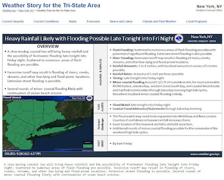
A flood watch has been issued from the National Weather Service for the next few days. Information is for local area around Teterboro Airport. For more information, please visit their website at: https://www.weather.gov/okx/
(To help support Bogota Blog NJ with its coverage of Local stories & sportsplease contribute at: donate to Bogota Blog NJ)
Flood Advisory
Flood Advisory National Weather Service New York NY 755 AM EDT Fri Sep 29 2023 -FLOOD ADVISORY IN EFFECT UNTIL 11 AM EDT THIS MORNING. -WHAT...Urban and small stream flooding caused by excessive rainfall is expected. -WHERE...Portions of southern Connecticut, including the following county, Fairfield. Portions of northeast New Jersey, including the following counties, Bergen, Essex, Hudson and Passaic. Portions of southeast New York, including the following counties, Bronx, New York (Manhattan), Rockland and Westchester. -WHEN...Until 1100 AM EDT. -IMPACTS...Minor flooding in low-lying and poor drainage areas. -ADDITIONAL DETAILS... - At 755 AM EDT, Doppler radar indicated heavy rain due to thunderstorms. This will cause urban and small stream flooding. Between 1 and 2 inches of rain have fallen. - Additional rainfall amounts of 1 to 3 inches are expected over the area. This additional rain will result in minor flooding. - Some locations that will experience flooding include... Yonkers, Paterson, Stamford, New Rochelle, Passaic, White Plains, Mott Haven, Bloomfield, East Tremont, Hackensack, Port Chester, Bergenfield, Paramus, Ridgewood, Lyndhurst, Rutherford, Secaucus, Rye, Tarrytown and Ridgefield. - http://www.weather.gov/safety/floodFLOOD WATCH REMAINS IN EFFECT THROUGH LATE TONIGHT...* WHAT...Scattered to Numerous Instances of Flash flooding Likely. Locally Considerable Flash Flooding is Possible. * WHERE...Portions of southern Connecticut, including the following areas, Northern Fairfield, Northern New Haven, Southern Fairfield and Southern New Haven. Portions of northeast New Jersey, including the following areas, Eastern Bergen, Eastern Essex, Eastern Passaic, Eastern Union, Hudson, Western Bergen, Western Essex, Western Passaic and Western Union. Portions of southeast New York, including the following areas, Bronx, Kings (Brooklyn), New York (Manhattan), Northeast Suffolk, Northern Nassau, Northern Queens, Northern Westchester, Northwest Suffolk, Orange, Putnam, Richmond (Staten Island), Rockland, Southeast Suffolk, Southern Nassau, Southern Queens, Southern Westchester and Southwest Suffolk. * WHEN...Through late tonight. * IMPACTS...Excessive runoff will likely result in scattered to numerous instances of flash flooding in urban and poor drainage areas. Locally considerable flash flooding is possible where axis of heaviest rain develops and sits for several hours. If this heavier rainfall axis develops over the flashy river and stream basins of northeastern NJ, Lower Hudson Valley, and southwestern CT, moderate flood stages could be exceeded. * ADDITIONAL DETAILS... - A widespread 3 to 5 inches of rain is expected, with localized amounts of 5 to 7 inches possible. -Rainfall rates of 1 to 2"/hr likely in heaviest rainfall axis, with rates in excess of 2"/hr possible. -Flooding will be exacerbated in coastal areas where heavy rainfall coincides with this morning and and evening high tides. -The exact axis of excessive rainfall is still uncertain, but those in the watch areas should prepare for the potential of considerable flooding. - http://www.weather.gov/safety/flood(To help support Bogota Blog NJ with its coverage of Local stories & sportsplease contribute at: donate to Bogota Blog NJ)


No comments:
Post a Comment
Note: Only a member of this blog may post a comment.